Architect and urban & computational designer Abhinav Bhardwaj made this great set of slides comparing urban design in the US and Europe, peppered with pithy observations like:
- European space is shaped on purpose: American open space is what’s left over.
- Small blocks make more corners, more routes, more street life.
- A fine grid offers hundreds of routes; the tree offers one way out.
I don’t think it’s great to generalize about “Europe” like this, but the points are still solid.
I don’t know. I don’t see any grids in Europe. Mostly, streets are named for the place they go to, so really just one way to get there unless you want to go way around
Tons of cities have grids, just maybe small ones. A theme in many places is to have an old downtown that has organic streets and a new downtown with a square grid, and then everything else is just a mess of straight and organic shapes.
Nearly all American cities are grids, so I don’t know what was trying to be said unless they’re just talking about suburban subdivisions
It honestly makes a lot of sense. Europe has a lot of urban fabric, which was build before the car. In most other continents, that is not the case, as urbanization happened later. That is not to say they do not have old cities, but for example a city like Bejing doubled in population since 1990. So a lot of urban fabric is actually new.
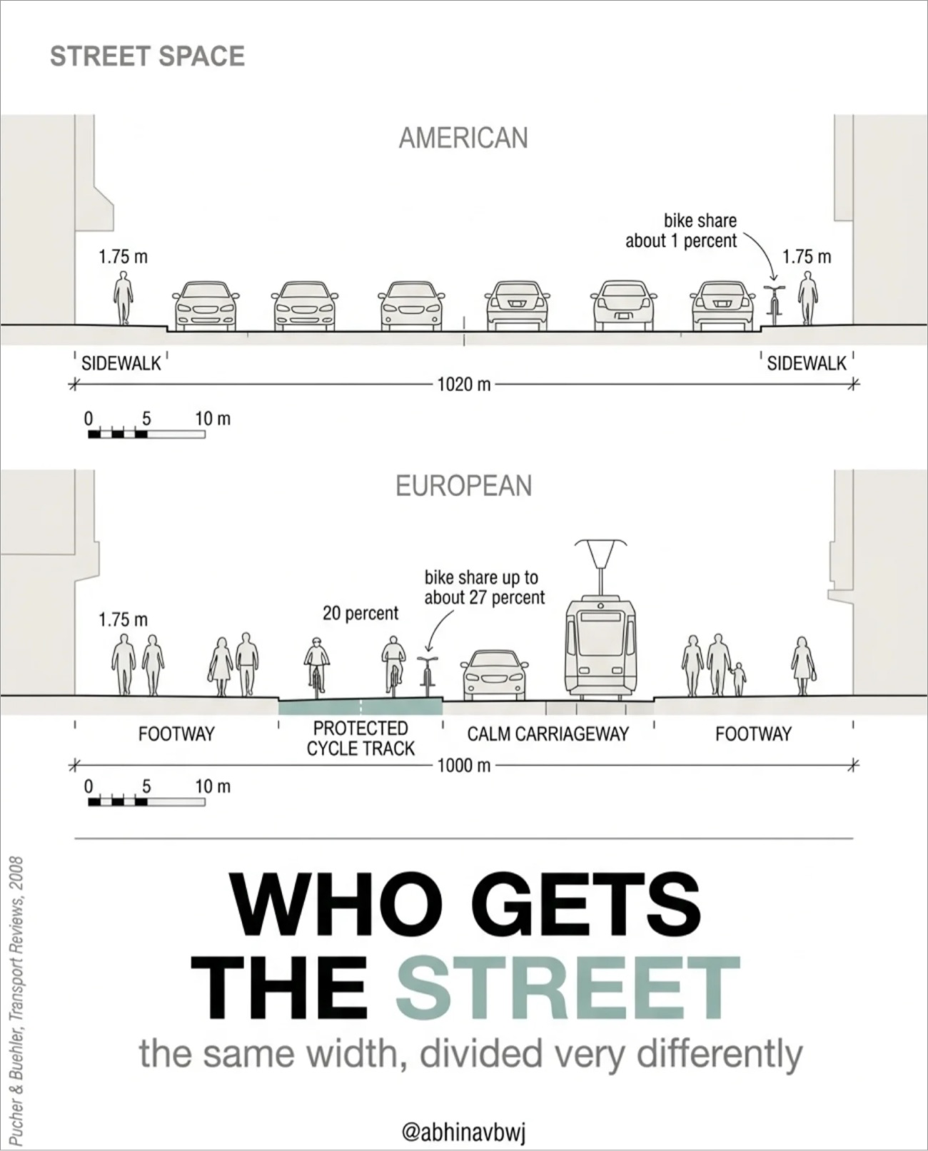
I still don’t understand why they labeled these streets as A THOUSAND METERS WIDE @.@
Not here to defend North American urban planning, but these diagrams make absolutely no sense. Also, both Europe and the Americas are highly diverse and cannot be generalized so easily.
Yup, definitely dealt with a depressing amount of car-only infrastructure on my trip through eastern Europe, even in cities with trams in some spots. I’d call the European diagram in the link the “European ideal” that cities try to strive for, and that north / western European places with lots of money are more often able to achieve than elsewhere on the continent.
But still makes you think. Europeans live closer together, way less space, but still use less space-efficient layouts. Sure, mostly not on purpose, grown that way over centuries. While industry quarters are closer to the american layout, less nice to walk.
Am I just not comprehending that first image? Are they saying that streets are 1km wide? And if we use the scale key, are they saying the average car is 5m wide?
The numbers are likely ai bullshit. The original image is from a published paper that didn’t have numbers on the graphic
To be clear, the European example is not representative of your average city street here, they moreso represent an ideal to strive towards